Seashells in rocks on mountain tops, underwater mountain chains, and continents that look like giant pieces of a global puzzle provide evidence that Earth’s continents and seafloors move and change over time.
The theory of plate tectonics explains processes in the geosphere that are fueled by Earth’s internal heat that have operated over billions of years. These changes can be imperceptible over a human lifetime or violent and abrupt, and continue to shape Earth’s environments.
On this page:
- What is plate tectonics?
- Earth system models about plate tectonics
- How human activities are influenced by plate tectonics
- Explore the Earth System
- Investigate
- Links to Learn More
For the classroom:
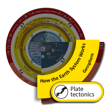
Global Change Infographic
The theory of plate tectonics explains process that shape the geosphere that are essential to How the Earth System Works. Click the image on the left to open the Understanding Global Change Infographic. Locate the plate tectonics icon and identify other Earth system processes and phenomena that cause changes to, or are affected by, plate tectonics.
What is plate tectonics?
As the young Earth cooled, layers formed and the most dense materials (primarily iron) sank to the middle (the core) of the Earth. Around the core formed the less dense layer called the mantle, topped by a thin layer called the crust. There are two kinds of crust: oceanic crust, which is found in ocean basins and the continental crust we live on that is made of lighter material than oceanic crust (to learn more about rock types, see the rock cycle page).
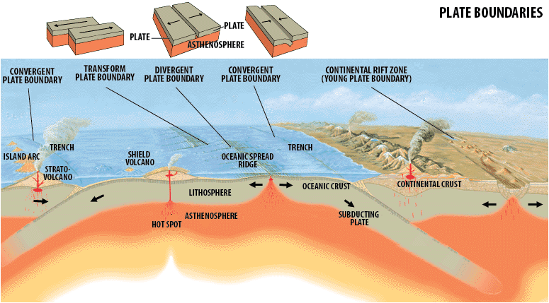
Modified from the USGS: Artist’s cross section illustrating the main types of plate boundaries (see text); East African Rift Zone is a good example of a continental rift zone. (Cross section by José F. Vigil from This Dynamic Planet — a wall map produced jointly by the U.S. Geological Survey, the Smithsonian Institution, and the U.S. Naval Research Laboratory.)
Although the crust and mantle are different in density and composition, the crust is attached to the uppermost part of the mantle, together forming the solid lithosphere. The lithosphere is broken up into huge sections, called plates that include both oceanic and continental crust. Below the lithosphere is a layer called the asthenosphere, which is a portion of the mantle that is weaker and less rigid due to pressure and temperature conditions. The rigid lithosphere moves on the asthenosphere both horizontally and vertically. Plates are constantly in motion, and move about 3 cm (a little over an inch) per year because of slow convection currents in the mantle due to Earth’s internal heat and pulling and pushing on the plates as they form, cool and sink back into the mantle. Through convection, hot regions of the asthenosphere heated from below rise closer to the surface, propelling the plates, and displace colder, denser material, which sinks back to lower parts of the mantle. Two additional processes, the sinking of old, cold and dense crust (slab pull), and the pushing of plates from ridges where plates form (ridge push), also contribute to plate movement.
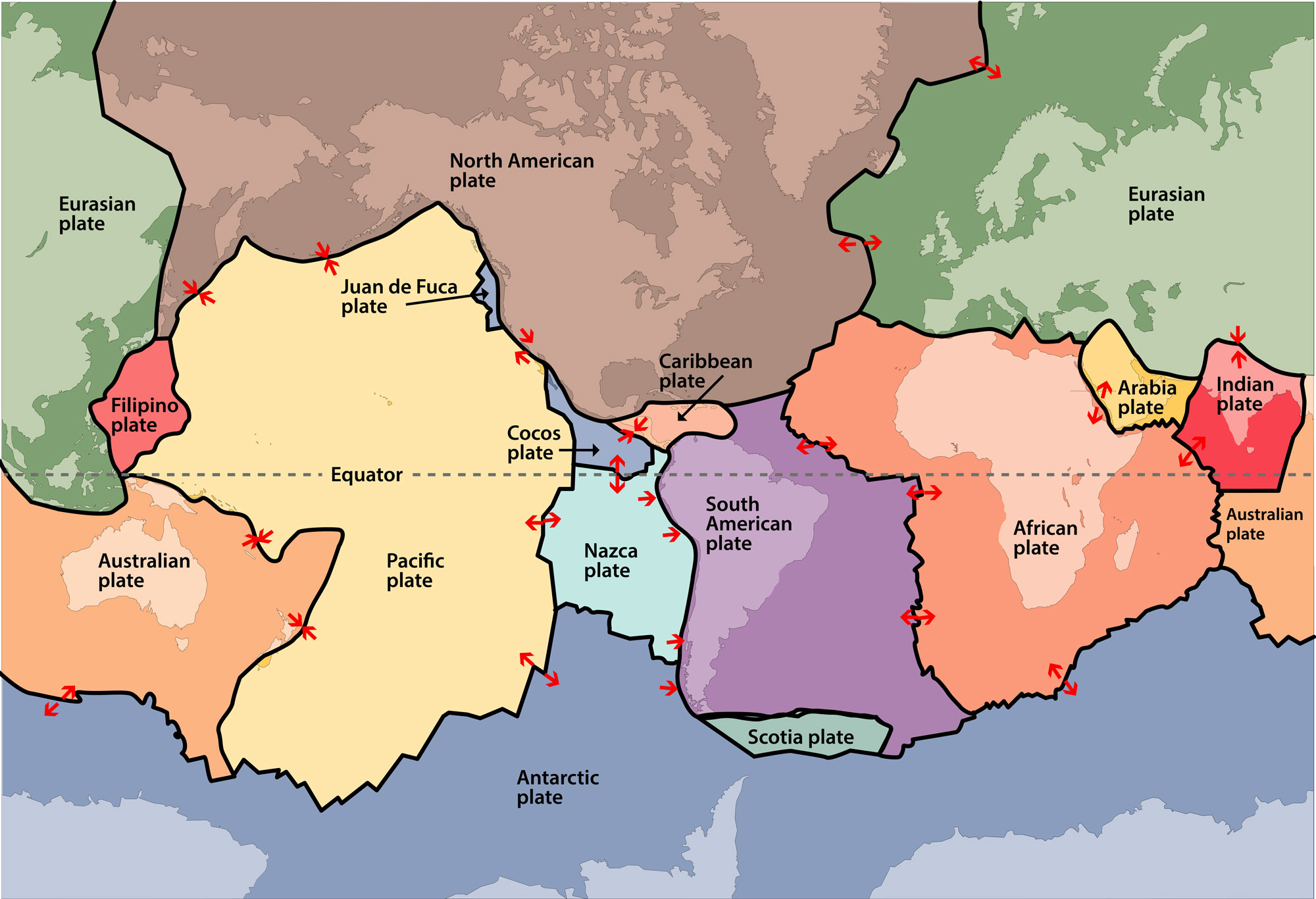
Map of tectonic plate boundaries
Plates interact in three ways: 1) Plates move away from each other at what are called divergent boundaries (also known as spreading centers); 2) Plates move towards each other at convergent boundaries, where continents collide creating mountain ranges or one plate sinks beneath another plate at a subduction zones and can form volcanic arcs; 3) Plates slide past each other at transform boundaries creating strike-slip faults. The uplift and sinking of land, earthquakes (the sudden release of energy that causes shaking), and volcanic eruptions are all evidence of interactions and stress due to the movement of the plates. Plate motion may seem slow, but over millions of years plate tectonics shapes the distribution of continents and oceans and mountain ranges that shape diverse ecosystems and influence global climate.
Earth system models about plate tectonics
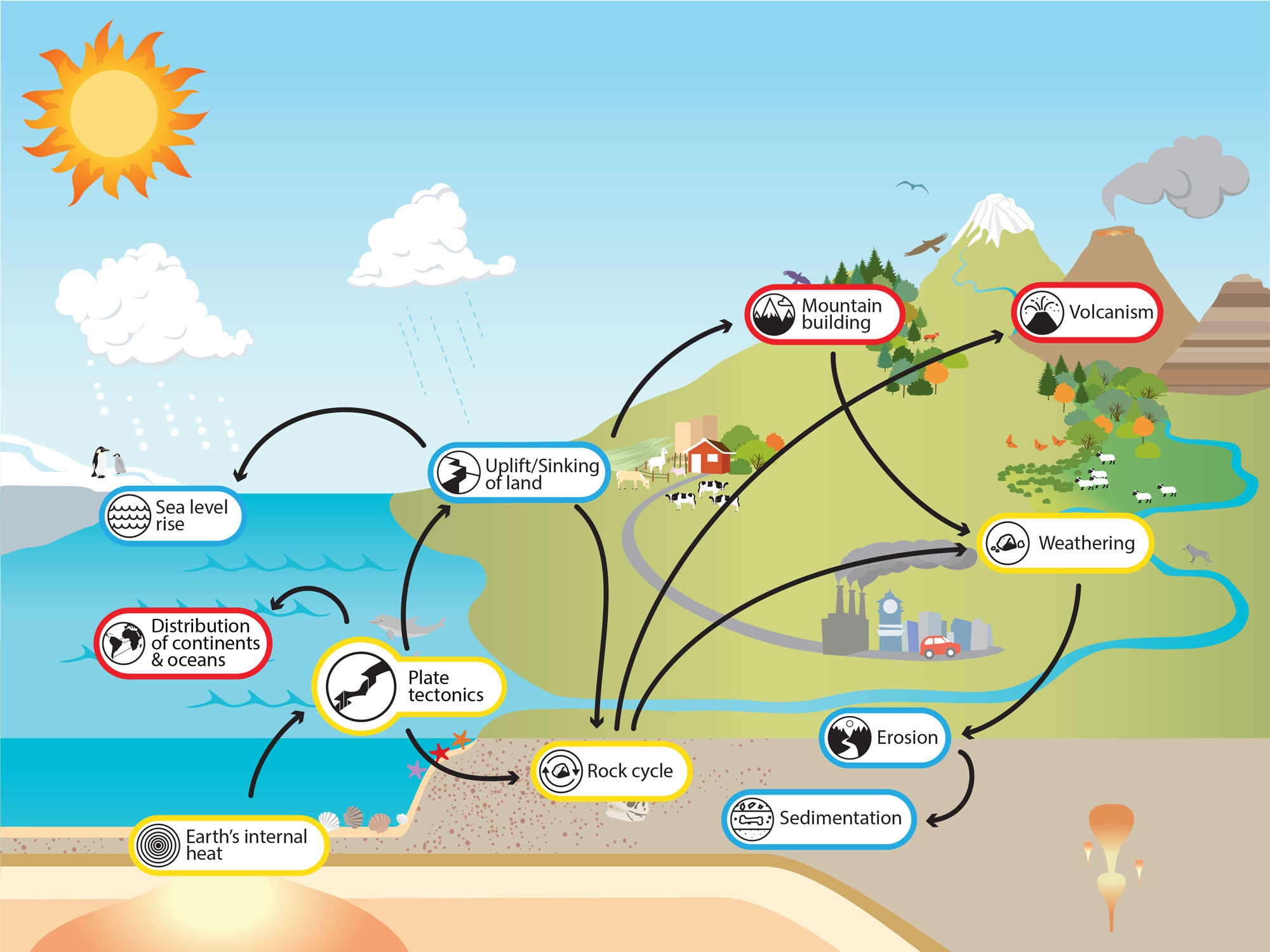
This Earth system model is one way to represent the essential processes that are related to plate tectonics, including Earth’s internal heat and the rock cycle. Hover over the icons for brief explanations; click on the icons to learn more about each topic. Download the Earth system models on this page.
Essential processes that are related to plate tectonics
Plate tectonics shapes global landforms and environments through the rock cycle, mountain building, volcanism, and the distribution of continents and oceans. These phenomena, ultimately driven by Earth’s internal heat, have far-reaching effects on other parts of the Earth system, including the sea level experienced along coastlines.
Some of the far-reaching effects of plate tectonics
How human activities are influenced by plate tectonics
Where and how humans live can be greatly affected by phenomena influenced by tectonic processes. Hover over or click on the icons to learn more about these Earth system connections.
Tectonic processes indirectly affect aspects of Earth systems that impact humans
Explore the Earth System
Click the icons and bolded terms (e.g. volcanism, rock cycle, etc.) on this page to learn more about these process and phenomena. Alternatively, explore the Understanding Global Change Infographic and find new topics that are of interest and/or locally relevant to you.
To learn more about teaching the plate tectonics, visit the Teaching Resources page.
Investigate
Learn more in these real-world examples, and challenge yourself to construct a model that explains the Earth system relationships.